
미리 보기 크기: 461 × 599 픽셀 다른 해상도: 185 × 240 픽셀 | 369 × 480 픽셀 | 802 × 1,042 픽셀
원본 파일 (802 × 1,042 픽셀, 파일 크기: 267 KB, MIME 종류: image/jpeg)
파일 설명
| 설명 |
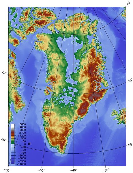
English: Topographic map of Greenland bedrock, in effect showing the topography without the extant ice sheet. Created using ETOPO1 Global Relief Model bedrock version from [1]. |
| 출처 | 자작 |
| 저자 | Skew-t |

|
이 그림 파일은 벡터 SVG 형식으로 다시 만들어야 합니다. SVG의 장점에 대해서는 여기(영어)를 참고해 주십시오. 만약 이 그림의 SVG 버전이 이미 존재한다면 이 틀을 {{vector version available|새 파일 이름.svg}}으로 대체해 주십시오.
|


라이선스
나는 아래 작품의 저작권자로서, 이 저작물을 다음과 같은 라이선스로 배포합니다:
이 파일은 크리에이티브 커먼즈 저작자표시-동일조건변경허락 3.0 Unported 라이선스로 배포됩니다.
- 이용자는 다음의 권리를 갖습니다:
- 공유 및 이용 – 저작물의 복제, 배포, 전시, 공연 및 공중송신
- 재창작 – 저작물의 개작, 수정, 2차적저작물 창작
- 다음과 같은 조건을 따라야 합니다:
- 저작자표시 – 적절한 저작자 표시를 제공하고, 라이센스에 대한 링크를 제공하고, 변경사항이 있는지를 표시해야 합니다. 당신은 합리적인 방식으로 표시할 수 있지만, 어떤 방식으로든 사용권 허가자가 당신 또는 당신의 사용을 지지하는 방식으로 표시할 수 없습니다.
- 동일조건변경허락 – 만약 당신이 이 저작물을 리믹스 또는 변형하거나 이 저작물을 기반으로 제작하는 경우, 당신은 당신의 기여물을 원저작물과 동일하거나 호환 가능한 라이선스에 따라 배포하여야 합니다.
파일 역사
날짜/시간 링크를 클릭하면 해당 시간의 파일을 볼 수 있습니다.
| 날짜/시간 | 섬네일 | 크기 | 사용자 | 설명 | |
|---|---|---|---|---|---|
| 현재 | 2010년 5월 26일 (수) 01:19 | | 802 × 1,042 (267 KB) | wikimediacommons>Skew-t | {{Information |Description={{en|1=Topographic map of Greenland bedrock, in effect showing the topography without the extant ice sheet. Created using ETOPO1 Global Relief Model bedrock version from [http://www.ngdc.noaa.gov/mgg/global/global.html].}} |Sour |
이 파일을 사용하는 문서
다음 문서 1개가 이 파일을 사용하고 있습니다: