The media handler extension for this file format is missing. Advanced media features may not work unless the file is viewed at 위키미디어 공용.

TIF 파일의 형식의 미리보기 크기: 800 × 396 픽셀. 다른 해상도: 320 × 158 픽셀 | 640 × 317 픽셀 | 1,024 × 507 픽셀 | 2,016 × 998 픽셀
원본 파일 (2,016 × 998 픽셀, 파일 크기: 3.06 MB, MIME 종류: image/tiff)
파일 설명
| 설명 |
English: Boundaries for California's 34th US Federal Congressional District. |
| 날짜 | |
| 출처 | GIS shapefile data created by the United States Department of the Interior, as part of the "1 Million Scale" geospatial data project. Retrieved from: http://nationalatlas.gov/atlasftp-1m.html?openChapters=#chpbound |
| 저자 | 1: GIS (congressional districts, 2013) shapefile data was created by the United States Department of the Interior. 2: Data was rendered using ArcGIS® software by Esri. 3: File developed for use on Wikipedia and elsewhere by 7partparadigm. |
라이선스
This map was obtained from an edition of the National Atlas of the United States. Like almost all works of the U.S. federal government, works from the National Atlas are in the public domain in the United States.
Online access: NationalAtlas.gov | 1970 print edition: Library of Congress, Perry-Castañeda Library
|
파일 역사
날짜/시간 링크를 클릭하면 해당 시간의 파일을 볼 수 있습니다.
| 날짜/시간 | 섬네일 | 크기 | 사용자 | 설명 | |
|---|---|---|---|---|---|
| 현재 | 2014년 3월 22일 (토) 12:35 | 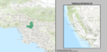 | 2,016 × 998 (3.06 MB) | wikimediacommons>7partparadigm | User created page with UploadWizard |
이 파일을 사용하는 문서
다음 문서 1개가 이 파일을 사용하고 있습니다: